Challenge & Context
Is it healthy going for a run in the city? Currently, a vast majority of the world’s large metropolitan areas face air pollution problems, and large European cities are not an exception: most of them experience or witness levels of local pollutant concentration higher than recommended by the World Health Organization (WHO) and the European Union (EU) itself.
Some pollutants that affect air quality, such as nitrogen oxides (NOX) and particulate matter (PM10 and PM2.5), are under strong discussion in the Smart Mobility or Smart industrial sector due to their direct impact on air quality. Unlike CO2 and other greenhouse gases that affect global warming in the long-run, local pollutants such as NOX and PM have direct implications on human health (in the case of people who reside or move around areas close to the emission source). In particular for those who carry out their professional and sports activities within the urban environment, the dispersion of pollutants is more difficult than in rural areas.
Running has been on an upward trend for some time. Recent years have placed running as the third most practiced sport by Spanish women and the fourth most practiced by men, according to the survey Sports Habits in Spain. The practice of sports, specially running, in urban areas, creates extensive direct contact with local pollutants as well as a higher inhalation of air: when you exercise and your muscles work harder, your body uses more oxygen and produces more carbon dioxide. To cope with this extra demand, your breathing has to increase from about 15 times a minute.
This increased exposure may raise some questions among the runners community:
- Is running in city air good for your health?
- What is the difference between jogging in an urban setting and jogging in a green area?
- Do I have to take any precautions?
Currently, most experts in the sports sector focus on the analysis of effects of pollutants on the global population, emphasizing the most vulnerable groups such as children and the elderly, but rarely referencing the impact of outdoor exercising in urban areas. Neither Internet searches provide a clearer picture as there is a wide disparity of opinions and positions on this topic. There is a general lack of information on how pollution may affect athletes and runners, as well as false myths about the practice of sports in cities. The good news is that it is becoming easier to access public information on real-time air quality indexes from pollutant measurement stations, but, far too often, these indicators are not representative for the entire city, presenting deviations of more than 50% in some cases. As a matter of fact, air quality monitoring stations and surveillance networks, as well as the dispersion models that offer an air quality map for the entire urban territory, help to obtain a global vision of atmospheric pollution, but do not allow for required detailed information in the specific areas of interest.
Solution
bettair® is an IoT platform that maps air and noise pollution in cities in real-time in a unprecedented scale, thanks to a large deployment of extremely accurate gas and other environmental sensors. The platform includes the hardware (gas sensor network), the software (back/front end) for cities and an app for residents.
For residents (exercising outdoors or not), this app delivers a high contribution to a comportment on health and well-being. This is because it is common understanding that practicing outdoor sports, but also walking, is associated with a healthy life, but what is still little known is the extent to which local pollution can counteract the positive effects of physical outdoor activity. To provide verified information on how pollution affects athletes and sports enthusiasts in cities, the Real Automóvil Club de Cataluña, S. L. (RACC), the largest automobile association in Spain with around 1 million members and experience in developing territorial analysis in relation to mobility and air quality, and Zurich Insurance Group, whose objective is to promote sports and a healthy life through sports races and marathons, have analysed the relationship between air quality and running by deploying the bettair static nodes in five Spanish cities: Madrid, Barcelona, Seville, Málaga and San Sebastian (the full study available at this link).
The study aimed at applying a novel methodology to find out the different levels of pollution in various zones of the city, at different times and days, to better guide athletes and sports enthusiasts as to when and where it is healthier to exercise. The analysis carried out by RACC and Zurich Insurance Group focused on providing runners with concrete/comprehensive information to allow them to make educated decisions related to the practice of sports, not least, with regards to scheduling their training sessions. The analysis also focused on people who do not practice sports regularly but wish to change their habits towards a more active life.
The work is structured in two different areas:
- an analysis of the opinions of experts to determine the impact of local pollutants on human health and the practice of sports in general;
- the results obtained from air quality measurements activities in each city, provided together with a technical interpretation of the results.
How it works
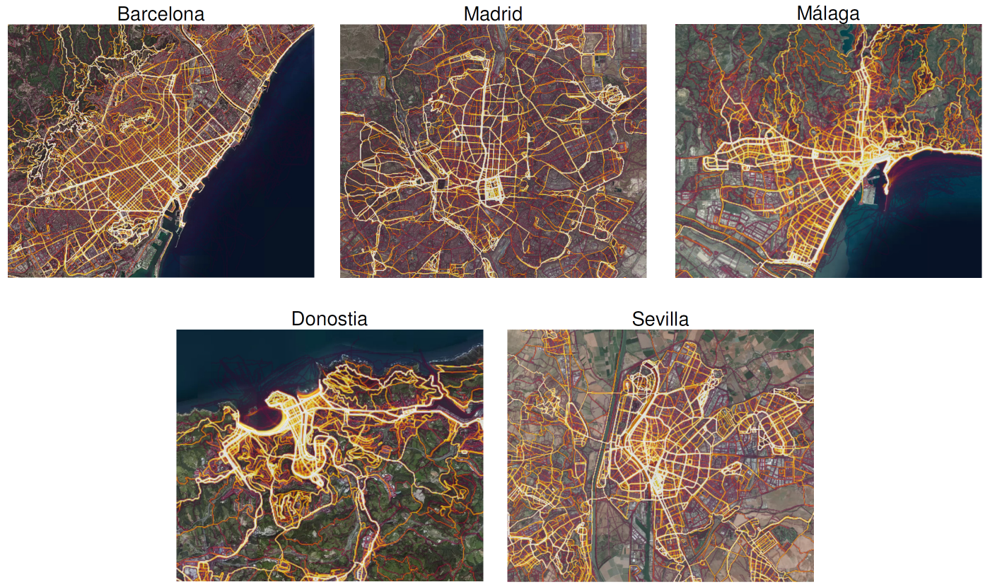
The selection of different measurement points in each city illustrates the differences between the quality of the air that athletes and runners breathe in different zones of the city (large road arteries, green areas and promenades). The points selected are located in various areas, but they have a common objective: demonstrate the quantity/influx of runners.
The high concentration of runners can be determined through heatmaps, which qualitatively indicate the routes and areas with the greatest influx of runners and which are published through diverse mobile sports applications. In the study, also data supplied by the Strava App, a GPS Cycling and Running App, was used. This app shows the aggregation of data from athletes who have recorded their training using the GPS of the mobile application itself. The transmitted information indicates the athlete’s trajectory, the length of the training session, and other other statistics.
Figure 1 . Monitoring Map
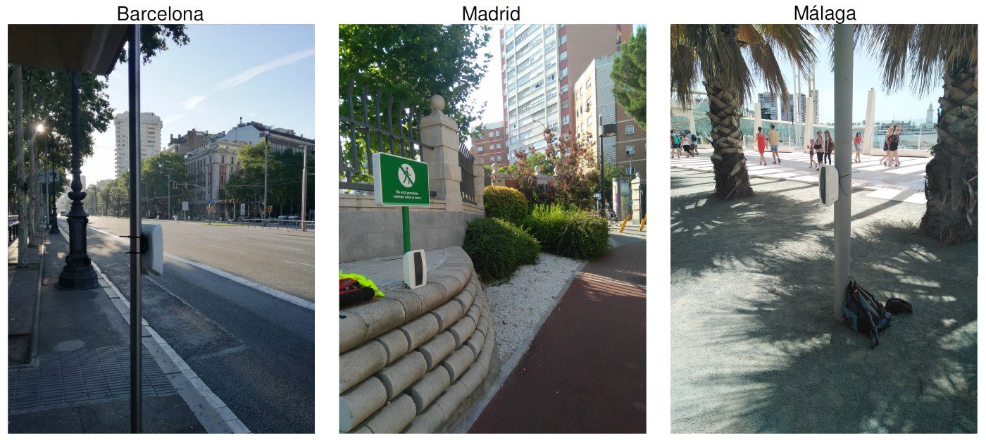
The study also aimed to examine which days of the week face a greater exposure to local pollution and to quantify the different effects, according to the hours of the day (e.g. morning, noon or afternoon). To generate and collect the required data, bettair static nodes were deployed in selected locations throughout the week. The raw data was sent in real-time to the cloud, where the post-processing algorithms of bettair were applied. The optimized data was then directly made accessible by the study’s researchers via the front-end software.
Figure 2 . bettair devices
The results of the analysis were provided to the five Spanish cities that annually host marathons organized by Zurich Insurance Group: Barcelona, Seville, Málaga and San Sebastian, as well as Madrid. Additional attention was paid to the geographic location of each city, as well as their climatology, population density, etc., to allow a wider range of measurements to be applied.This allowed further information to be collected from metropolitan areas with different impacts on the dispersion of pollutants that affect air quality: temperature, rain patterns, maritime influence, altitude, urban distribution or the number of inhabitants.
Due to the availability of public data being limited, polluting gases and particulates concentrations data were collected from the scratch using bettair devices (nodes) located in different geographical points strategically selected in a total of five Spanish cities. This comprehensive approach allowing comparative analysis has been chosen in such a way for the very first time in Spain to also allow a top quality and scalable data and information generation for the future.
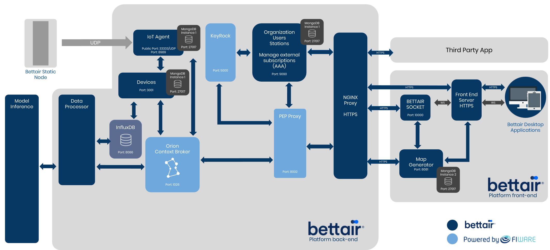
To meet users’ expectations, bettair, a FIWARE Foundation’s Gold member, developed an AI-based, cost-effective sensor platform solution to map air quality in real-time and with an accuracy rate fairly close to the one delivered by large and expensive air quality monitoring stations. Based on the large deployment of outstandingly accurate, ultra-reliable IoT sensors, this “Powered by FIWARE” solution provides today a highly efficient and versatile pollution-mapping tool for cities.
Figure 3 . Architecture
bettair leverages the Connecting Europe Facility Context Broker (“Context Broker”) for a united platform based on a micro-service architecture. The Context Broker allows the platform to handle large amounts of data and to create a more user-friendly platform while it enables bettair to create interoperable and seamless connections to cities’ platforms.
Benefits & Impact
Let’s go back to our initial question: Is exercising in city air good for your health? The answer is crystal clear: it is always appropriate doing exercise, but the challenge is to understand better, easier and in real-time where air quality is appropriate or poor. As poor air quality has negative consequences for people’s health and quality of life we should not forget that practicing outdoor physical activity is however considered positive to stay healthy and fit. Therefore, runners, as a dominant outdoor sports practising group, do good to understand when and where to expose themselves to as little pollutants as possible. Depending on the location and time of the day, the pollution exposure can be reduced by six to ten times.
As of today, it is hard to find a city that is able to manage information on air quality at street accuracy level. The current dispersion models based on data from “traditional” air quality monitoring stations, which are usually just a few and with far distances between them, are unable to obtain information on pollutant concentrations in specific streets, a given area or full city. So far, there have not been any mobile platforms or applications available that provide this type of information to athletes, hobby runners or walkers to help them to plan their exercising and training routes. The mentioned study recommends public administrations to create a more extensive network of measurement points in their cities that allows data collection across the whole city while reducing error margins at the same time. Such solutions may allow data and information on air quality to be disseminated in real-time so that the citizen can easily understand his/her level of exposure to air pollutants and consequently perform educated decisions with regard to their moves in the city.
The five cities included in the mentioned research of RACC and Zurich Insurance cover an aggregated population of 6.2M with round about 650k runners (considering a share of 10,5% of the population being occasional or regular runners).
Added value through FIWARE
Previous solutions were developed using a monolithic architecture with running services deployed as a united solution. Such applications may be developed if they remain limited in size and not having any requirement of scalability. Additionally, monolithic applications are difficult to govern and to modify. Today’s common request, even pre-requisite, of scalability can only be achieved by running multiple instances based on a network load balancer. As meeting scalability requirements was one of the main priorities for bettair, ,a new approach was required. With the support of FIWARE, they designed the new platform using a micro-service architecture. This architecture uses FIWARE out-of-the-box components such as the FIWARE Generic Enablers to allow each service to be independent from the others and therefore also be deployed independently.
It is also to underline that the architecture developed by bettair allows the creation of sub-networks between components in order to improve the performance of the platform. This also increases security (such as GDPR) since only specific components are exposed to external networks.
Next Steps
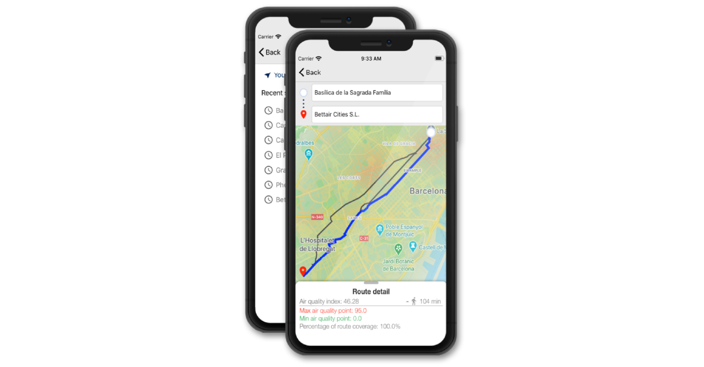
Following the citizens’ needs for real-time information on air quality at more filigran level (as suggested by the study) bettair has been developing a mobile App to calculate individual exposure to air pollutants as well as to indicate less polluted routes for walking, running or biking.
Figure 4 . Mobile App
Citizens’ awareness for air pollution is one of the main drivers of the growing demand for portable air quality monitors. They continue to show significantly growing interest when it comes to their exposure to air pollutants. The availability of highly localised air quality data is becoming critical to the empowerment of citizens so that they can autonomously make their best choices for themselves about which air quality they breathe. Thanks to the bettair, citizens will be able to choose where and when they want to run, walk, or play — or in the future, even where to buy a house.
References
- Estudio Practica Deportiva y Calidad Del Aire en Ámbitos Urbanos.
- Alastuey, A; Querol, X. “La contaminació urbana procedente del transport. La situació actual a Espanya” (2018).

